Binnypet–Bellandur Road Suburban Rail Corridor
If the caption does indeed attract you, then read on. I am no civil engineer who is well aware of the nitty-gritty of building rail projects but just an ordinary Bangalorean who is concerned about the well being of my lovely city and its people. This article is more of a thought experiment if I can call it that.
Please feel free to point out the mistakes in this as I am fully aware that it is not 100 percent accurate. The intention behind this blog is to present it as a suggestion to the Bangalore Comprehensive Mobility Plan. I may have committed mistakes as the blog is being written in a hurry without much consideration towards the presentation aesthetics.
Bangaloreans needn't really be apprised of the potential that the rail-based mode of transport holds in the context of addressing the city's infamous traffic. While the metro project is heading in some direction, the suburban rail that the city is eagerly awaiting appears to be directionless. Considering the amount of money the state government is willing to spend on elevated corridors (that would do the city no good), we the citizens of Bangalore can certainly propose that a suburban rail corridor that passes through the city center be built.
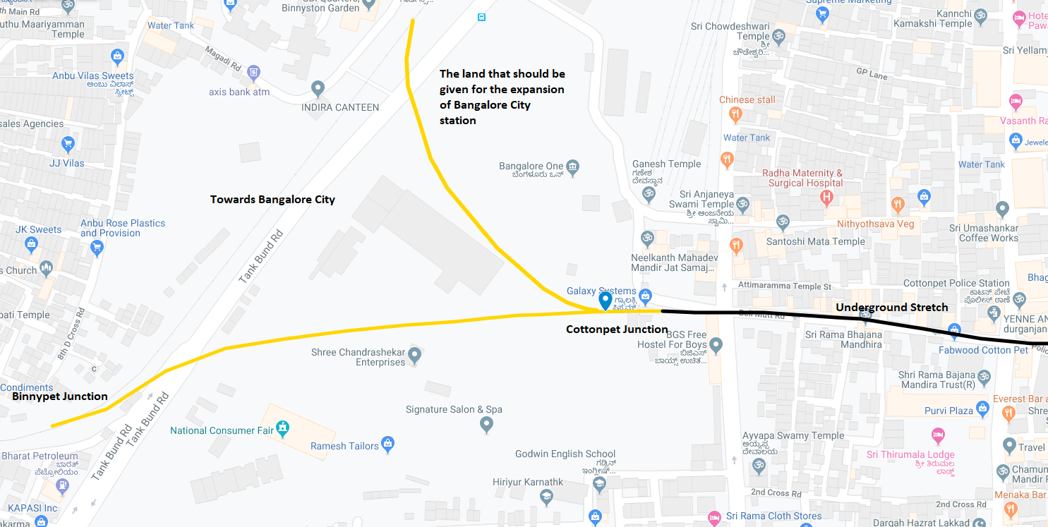
A new line deviating from the existing Bangalore - Mysore line must be laid towards the Binny Mill land. Binnypet junction would become a junction where lines coming from Bangalore City station and the Mysore side of the railway line would meet. Cottonpet would be another junction where the lines coming from the City station and Binnypet, meet. The lines in yellow indicate that they are running at grade.
I have never read of any suburban line being built underground, but I somehow don't feel it is impossible. Tunnels were bored between Shivashankar Circle in Basavangudi to Mantri Square in Malleshwaram passing through densely populated areas such as KR Market, Chikpet, Tulasi Thota and Majestic for the Green Line of Bangalore Metro. Would it be impossible to do so for the suburban rail between Binny Mill Circle and Chikpet metro station? I would need an expert to confirm that for me. Anyway, the lines in black signify that they run underground.
There should be an underground station at Cottonpet, for which land acquisition would be necessary to serve the requirements of all the surrounding areas such as Binnypet, Cottonpet, Sultanpet, and Ranasingh Pet; the next station would also be an underground station below the metro's Green Line at Chikpet, thereby serving as an interchange point.

After Chikpet, the line moves on to touch the most important places in Bangalore--KR Market. Providing suburban rail connectivity to the city's busiest market would transform the transportation dynamics.

The KR Market station should be located in the space that is currently vacant owing to the demolition of Parimala, Apsara, and Pradeep theaters, as it is equidistant from Kalasipalya BMTC bus station and the KR Market. This station should also be located underground.
From Kalasipalya onwards, the line would continue below the roads of Kumbaragundi/Journalists' Colony to eventually stop at JC Road or proceed a little further so that a station can come up at a point equidistant from both JC Road and Lalbagh Road. Here the line would be aligned parallel to the drain that runs from Kalasipalya via JC Road (the hump near church), and Lalbagh Road (near the passport office). It would continue parallel to the drain to eventually resurface at Shantinagar. Going at grade by covering the drain and laying tracks over it so that land acquisition is necessary only for the stations, is also an option.

Since it costs me nothing to mark the stations here, I am marking as many stations as possible. If one were to implement this in reality, the number of stations would certainly be lower.
Anyway, at Shantinagar, the tracks would resurface on the ground at the government land belonging to the KSRTC and BMTC, so that we have an interchange station for the benefit of commuters. Shantinagar station would also serve the residents of Sudhamanagar, Wilson Garden, Langford Town etc.
Beyond Shantinagar, things get more complicated as land acquisition becomes necessary, which is certainly not easy. But the government has to do it in the interest of the city as well as that of the residents of those areas who do not have the best of transport infrastructure. If they are suitably compensated, then a lot of these messed up areas can be rebuilt to have better roads, greenery, etc. The second complication is that from here onwards, the line will have to pass through the land belonging to the Ministry of Defence.

Anepalya, the junction of Hosur and Bannerghatta roads, must have a junction followed by Neelasandra, which is densely populated and has extremely bad infrastructure. Here, if the land acquisition is found to be challenging, then the track could once again go underground touching the vicinity of National Games Village so that Koramangala gets the benefit of the track. Finally, it would pass through the defence land in Ejipura to touch the Koramangala - Domlur road. How easy is it to get the defence ministry nod for infrastructure projects???? Not easy as we have seen, but a project of this scale, where the center too is involved, a win-all model should be worked out to lay tracks through the defence land.
The IT zone begins from Domlur onwards. Therefore, closer the line goes to the business parks, the better.

A railway line wouldn't really damage Bellandur lake as it would not release effluents or sewage into the lake (as suburban trains have no toilets there is no fear of human excreta falling on the tracks). The localities of B Nagasandra and Yemalur have a good population that the stations can serve; as a matter of fact, the Belur Nagasandra station would also serve Murugeshpalya. As the land around these areas mostly belongs to the central government agencies such as HAL, DRDO etc., procuring it for a railway line may not be impossible.

The red line beyond Yemalur indicates a thickly populated region where land acquisition could be difficult. However, having a suburban train station close to the Prestige Tech Park could solve a good portion of the traffic mess around Marathalli and Kadubeesanahalli areas. Beyond PTP, the line could traverse next to the channel between the Bellandur and Varthur lakes to join the Bangalore - Salem railway line just before the Bellandur Road station.
2.) The "survey" that I have prepared is a very very crude one and naturally does not take into consideration all the challenges that may arise during the course of implementing the project, which in reality would decide the feasibility of this proposal.
3.) Land acquisition has to be done where necessary although it can be tied to a minimum.
4.) Since the railway line cuts through the defence land, The Ministry of Defence should have the final say in terms of safeguarding its property on either side of the tracks. Personally, I feel they should encourage it as rail connectivity to their property helps them move the people and may be logistics into and out of their locations more easily.
5.) The line knocks of multiple BMTC routes like the ones between Majestic and KR Market to Shantinagar, Anepalya, Neelasandra, Ejipura, B Nagasandra, Marathalli (just partially).
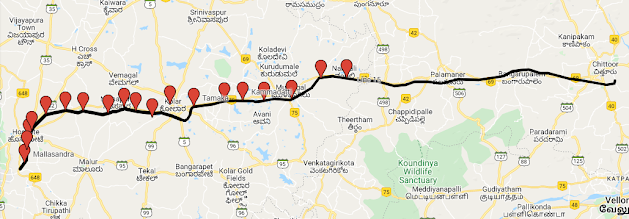
6.) In future, the line can be extended to Marikuppam by laying another line that branches off at Carmelaram and touching the vicinity of Sarjapur, Mugalur, Chikka Tirupati, Jayamangala, Masti, Budikote, and Kamasamudram. Basically, it would eliminate the "dead-end" nature of Marikuppam besides providing rail connectivity to the hitherto unconnected areas of Kolar district. Such a proposal would turn Kolar to Bangalore what Noida is for Delhi.
7.) The complete map of the line would be as below:

In future, the nearly abandoned Baiyappanahalli - Vimanapura railway line can be linked to this line at Murugeshpalya by routing it underground through the HAL Airport as below:

Thanks for Reading :-)
Please feel free to point out the mistakes in this as I am fully aware that it is not 100 percent accurate. The intention behind this blog is to present it as a suggestion to the Bangalore Comprehensive Mobility Plan. I may have committed mistakes as the blog is being written in a hurry without much consideration towards the presentation aesthetics.
Bangaloreans needn't really be apprised of the potential that the rail-based mode of transport holds in the context of addressing the city's infamous traffic. While the metro project is heading in some direction, the suburban rail that the city is eagerly awaiting appears to be directionless. Considering the amount of money the state government is willing to spend on elevated corridors (that would do the city no good), we the citizens of Bangalore can certainly propose that a suburban rail corridor that passes through the city center be built.
Achieving this requires the railways to take possession of the land currently owned by the Binny Mill.
A new line deviating from the existing Bangalore - Mysore line must be laid towards the Binny Mill land. Binnypet junction would become a junction where lines coming from Bangalore City station and the Mysore side of the railway line would meet. Cottonpet would be another junction where the lines coming from the City station and Binnypet, meet. The lines in yellow indicate that they are running at grade.
I have never read of any suburban line being built underground, but I somehow don't feel it is impossible. Tunnels were bored between Shivashankar Circle in Basavangudi to Mantri Square in Malleshwaram passing through densely populated areas such as KR Market, Chikpet, Tulasi Thota and Majestic for the Green Line of Bangalore Metro. Would it be impossible to do so for the suburban rail between Binny Mill Circle and Chikpet metro station? I would need an expert to confirm that for me. Anyway, the lines in black signify that they run underground.
There should be an underground station at Cottonpet, for which land acquisition would be necessary to serve the requirements of all the surrounding areas such as Binnypet, Cottonpet, Sultanpet, and Ranasingh Pet; the next station would also be an underground station below the metro's Green Line at Chikpet, thereby serving as an interchange point.
After Chikpet, the line moves on to touch the most important places in Bangalore--KR Market. Providing suburban rail connectivity to the city's busiest market would transform the transportation dynamics.
The KR Market station should be located in the space that is currently vacant owing to the demolition of Parimala, Apsara, and Pradeep theaters, as it is equidistant from Kalasipalya BMTC bus station and the KR Market. This station should also be located underground.
From Kalasipalya onwards, the line would continue below the roads of Kumbaragundi/Journalists' Colony to eventually stop at JC Road or proceed a little further so that a station can come up at a point equidistant from both JC Road and Lalbagh Road. Here the line would be aligned parallel to the drain that runs from Kalasipalya via JC Road (the hump near church), and Lalbagh Road (near the passport office). It would continue parallel to the drain to eventually resurface at Shantinagar. Going at grade by covering the drain and laying tracks over it so that land acquisition is necessary only for the stations, is also an option.
Since it costs me nothing to mark the stations here, I am marking as many stations as possible. If one were to implement this in reality, the number of stations would certainly be lower.
Anyway, at Shantinagar, the tracks would resurface on the ground at the government land belonging to the KSRTC and BMTC, so that we have an interchange station for the benefit of commuters. Shantinagar station would also serve the residents of Sudhamanagar, Wilson Garden, Langford Town etc.
Beyond Shantinagar, things get more complicated as land acquisition becomes necessary, which is certainly not easy. But the government has to do it in the interest of the city as well as that of the residents of those areas who do not have the best of transport infrastructure. If they are suitably compensated, then a lot of these messed up areas can be rebuilt to have better roads, greenery, etc. The second complication is that from here onwards, the line will have to pass through the land belonging to the Ministry of Defence.
Anepalya, the junction of Hosur and Bannerghatta roads, must have a junction followed by Neelasandra, which is densely populated and has extremely bad infrastructure. Here, if the land acquisition is found to be challenging, then the track could once again go underground touching the vicinity of National Games Village so that Koramangala gets the benefit of the track. Finally, it would pass through the defence land in Ejipura to touch the Koramangala - Domlur road. How easy is it to get the defence ministry nod for infrastructure projects???? Not easy as we have seen, but a project of this scale, where the center too is involved, a win-all model should be worked out to lay tracks through the defence land.
The IT zone begins from Domlur onwards. Therefore, closer the line goes to the business parks, the better.
A railway line wouldn't really damage Bellandur lake as it would not release effluents or sewage into the lake (as suburban trains have no toilets there is no fear of human excreta falling on the tracks). The localities of B Nagasandra and Yemalur have a good population that the stations can serve; as a matter of fact, the Belur Nagasandra station would also serve Murugeshpalya. As the land around these areas mostly belongs to the central government agencies such as HAL, DRDO etc., procuring it for a railway line may not be impossible.
The red line beyond Yemalur indicates a thickly populated region where land acquisition could be difficult. However, having a suburban train station close to the Prestige Tech Park could solve a good portion of the traffic mess around Marathalli and Kadubeesanahalli areas. Beyond PTP, the line could traverse next to the channel between the Bellandur and Varthur lakes to join the Bangalore - Salem railway line just before the Bellandur Road station.
A few more points
1.) I once again repeat that I am no professional surveyor but just an ordinary citizen concerned about the city of Bangalore that has given me, my parents and my grandparents everything to lead a good life.2.) The "survey" that I have prepared is a very very crude one and naturally does not take into consideration all the challenges that may arise during the course of implementing the project, which in reality would decide the feasibility of this proposal.
3.) Land acquisition has to be done where necessary although it can be tied to a minimum.
4.) Since the railway line cuts through the defence land, The Ministry of Defence should have the final say in terms of safeguarding its property on either side of the tracks. Personally, I feel they should encourage it as rail connectivity to their property helps them move the people and may be logistics into and out of their locations more easily.
5.) The line knocks of multiple BMTC routes like the ones between Majestic and KR Market to Shantinagar, Anepalya, Neelasandra, Ejipura, B Nagasandra, Marathalli (just partially).
6.) In future, the line can be extended to Marikuppam by laying another line that branches off at Carmelaram and touching the vicinity of Sarjapur, Mugalur, Chikka Tirupati, Jayamangala, Masti, Budikote, and Kamasamudram. Basically, it would eliminate the "dead-end" nature of Marikuppam besides providing rail connectivity to the hitherto unconnected areas of Kolar district. Such a proposal would turn Kolar to Bangalore what Noida is for Delhi.
7.) The complete map of the line would be as below:
In future, the nearly abandoned Baiyappanahalli - Vimanapura railway line can be linked to this line at Murugeshpalya by routing it underground through the HAL Airport as below:
Thanks for Reading :-)
Nice ideas!! Hope at least part of this gets exexuted.
ReplyDelete