Magadi on the Rail Map
Several buses ply between the city and Magadi and the region is poised for immense growth in the days to come, thanks to projects such as Nadaprabhu Kempegowda Layout and the Major Access Road (MAR). BMRCL’s plans for Magadi road to connect Hosahalli and Kadabagere Cross in phase 3, cannot produce the required results in terms of simplifying commuting on Magadi Road.
It is worth noting that there is traffic on the Bangalore-Magadi and Magadi-Kunigal routes. Therefore, leveraging the Bangalore suburban rail project to put Magadi on the rail map can be of immense use to a million people in less than a decade from now.
A very legitimate concern regarding such a project for the government is land acquisition. If technology is used, then the railway line can be laid with minimal acquisition of land. But how?
The Arkavathi Pipeline Road!

The Arkavathi pipeline road runs from Tippagondanahalli to the Rajajinagar water tank near the sub-registrar office. It provides connectivity to some of the densely populated areas such as Sunkadakatte, Herohalli Cross, Andrahalli main road, and Tavarekere.
If the defunct pipeline were to be replaced by two electrified broad gauge rail tracks, then the commuting scenario in West Bangalore would undergo a sea change.
The pipeline could be laid below the ground as done in Tendersure roads when the government would pump the water from the Tippagondanahalli dam to Bangalore City. The Internet-of-Things (IoT)-based approaches can help the BWSSB track leakages even then.
Now the question arises on how to link this track to the Bangalore-Tumkur railway line near Rajajinagar. The pipeline road ends at the Rajajinagar water tank located between Rajkumar road and the Chord road. If we look at the portion beyond, although there is developed land, we do see some vacant land, most of which is probably not owned by private parties. Here is a screenshot:

Let’s zoom in a little and see the landscape in the satellite view:

The Landscape Between Rajkumar & Chord Roads on the Extended Portion of Pipeline Road

The playground of Vivekananda College will have to be acquired for the project. The Milk Colony Park described in the map will have to be taken over, in addition to some land that may be owned by the Teresa Hospital.
Considering the above suggestions, one possible alignment of the Bangalore-Magadi-Kunigal Railway Line would be as below:

The next few images would be the zoomed-in versions of the above image depicting the individual sections of the complete line.

The line branches off from the Bangalore-Tumkur railway line at Rajajinagar, right beside the Brigade Gateway, and continues through the Milk Colony Park and Vivekananda College Grounds and probably, the land belonging to Teresa Hospital.

There is a dip in the gradient between Rajajinagar and Laggere (on the ORR) and again a fairly steep ascent towards Sunkadakatte, due to the Malagala valley through which a tributary of the Vrishabhavati flows parallel to the ORR. It’s presently called Vrishabhavati Nagar. Depending on the technicalities associated with the acceleration and deceleration of a train in both directions, building a viaduct across the Malagala Valley between the Vrishabhavati Bank and Laggere stations may be required. Naturally, the track cannot intercept the super-busy ORR at grade.


There are a lot of residential localities in the vicinity of the project such as Nagarbhavi, Herohalli, Andrahalli, Anjana Nagar, Nagarahole Nagar, Tigalarapalya, Vighneshwar Nagar, etc., but they are all unplanned, with inadequate road connectivity. As you may be aware, Magadi Road from the Mysore Road Circle in Chamarajpet to Magadi is inadequate for the traffic it handles.


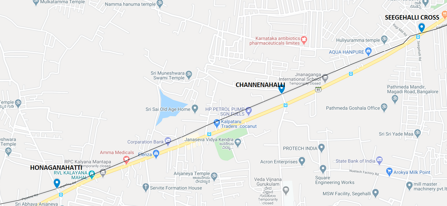


Gangappanahalli station would solve the commuting woes of people who have purchased sites in the private layouts in and around Chandrappa Circle, Big Banyan Tree, and Ramohalli, but are wary of shifting there due to the difficulties associated with commuting to the office. BMTC buses commencing from some of the villages in Ramanagar district such as Manchanabele, Dabbaguli, VG Doddi, Katamanadoddi, Hagalahalli, etc., instead of going all the way to KR Market via Kengeri or Tavarekere, can connect to these stations.
If developed with viewpoints and perhaps a ropeway to the Goravanahalli (visible in the image above), which is a narrow strip of land between the rivers of Kumudwathi and Arkavathi, Tippagondanahalli dam would be a major tourist hub for visitors from Bangalore.


Magadi is important for Bangalore from a tourism standpoint as it houses two of the important temples—Magadi Ranganatha Swamy (towards Bangalore) and Prasanna Someshwara (towards Kunigal/Huliyurdurga).
Beyond Magadi town, on the road leading to Kunigal, is a ridge point where the rainwater flowing into the rivers Shimsha and Kanva is located. Since the junction where roads connecting Magadi to Kunigal and Kudur (& also Tumkur) is at a stone throw distance, it can be an important transit point for switchover to buses. Hence a station is required near the ridge.
Kempapura is where the tomb/mausoleum of Kempegowda (I am unsure if it is of Kempegowda I or his grandson Kempegowda II) is located. Connecting it by rail would be a boost to tourism.
Latest Developments
Hon’ble Deputy CM, Dr. Ashwath Narayan, who hails from Magadi, and is also the Ramanagar district in-charge minister, recently announced the setting up of a Sanskrit University in Magadi, besides an industrial area for the town. The survey for creating a Bangalore City-Magadi-Kunigal suburban rail corridor, will have to factor these aspects and ensure these sites receive the benefits of rail connectivity.
If the land acquisition near Rajajinagar proves challenging, then an alternative can be worked out.

Now let us zoom in the above portion and see how things would appear on ground.

In case, laying a railway line directly from the Bangalore City station is not possible, the line can deviate from the Mysore line at a suitable point and run parallel to the drain that runs in between the rail track and Magadi Road, as shown above.


From Bedarahalli onwards, the line would take the same alignment as the one proposed, which is the Arkavathi pipeline road.
I am no professional surveyor or a civil engineer, but an ordinary Bangalorean who would love to see my city have the best-in-class infrastructure. Bangalore should have railway lines along all the major roads emanating from it.
Comments
Post a Comment